Extreme conditions such as warm sea-surface temperatures are fueling an active hurricane season, but they are taking their toll on the Atlantic basin's tropical coral reefs.
The 2010 Atlantic hurricane season has thus far already been the most active since the epic 2005 season when several hurricanes plowed through the Caribbean and that year, like this year, thermal stress is taking its toll on the region's coral.
According to a statement released last week by NOAA, a strong potential for bleaching now exists in the Caribbean and it could be as severe as in 2005 when over 80 percent of corals bleached and over 40 percent died. Prolonged coral bleaching, can lead to coral death and the subsequent loss of coral reef habitats for a range of marine life. This is more than likely attributed to extremely warm and unprecedented sea surface temperatures. High temperatures cause corals to force out the symbiotic algae that provide them with food. This makes the corals appear white or 'bleached' and can increase outbreaks of infectious disease. The decline and loss of coral reefs has significant social, cultural, economic and ecological impacts.
It is still too early to tell the long-term effect and severity of this year's coral bleaching but the 2005 bleaching event was the result of the largest, most intense thermal stress ever recorded in the Caribbean during the 25-year NOAA satellite record.
I created a graphic this morning for The Northeast Quadrant's Facebook page WEATHER PHOTO OF THE DAY album which depicts satellite images of the four category 4's of 2010 (so far), featuring Hurricanes Danielle, Earl, Igor and Julia.
These four storms were classic Cape Verde hurricanes and while Danielle and Julia remained out to sea, Earl and Igor directly and indirectly impacted land mass. Both Igor and Julia attained category 4 strength simultaneously – an occurrence that has not happened since September 16, 1926.
I thought this was a pretty cool way of showing that no two storms are alike despite their similar characteristics!
After a slow start to a hurricane season that was hyped to be anything but slow, today marks the first full day since the development of Tropical Depression #6 on August 21 (which would later become Hurricane Danielle) that we've gone without a named storm in the Atlantic basin. Although we almost did it between September 5–6 when Hurricane Earl dissipated in the north Atlantic, we were surprised when Tropical Depression #10 (which would later become Tropical Storm Hermine) quickly spun up in the southwestern Gulf of Mexico before making landfall in extreme northeastern Mexico. This marks a total of 36 days having a named storm, the longest such period since the 2002 Atlantic hurricane season, which had remained completely active for 45 days from August 29 through October 12.
We are well into an above-average Atlantic hurricane season with 13 named storms and two unnamed tropical depressions, and there are only eight more names available for use before we'd need to break into Greek alphabet, which has only been done once in history – during the epic 2005 Atlantic hurricane season. With that said, today's break in activity leaves us on edge after yesterday's degeneration of both Lisa and Matthew, wondering where Nicole is... and will Otto follow?
According to the National Hurricane Center (NHC) there is an increasingly likely chance we'll see our next named storm this week as an area of convection continues to flare up in the northwest Caribbean Sea which in the short-term seems to have its eyes on the southeastern Gulf coast. Meanwhile, a very small area of convection flared overnight in the central Atlantic, but development of this system is not likely in the near-term.
There is not yet an official invest on the system in the Caribbean but by day's end I would expect to see 96L pop up! At that time the computer models should have a better handle on what the system might do – where it might go, how fast it might develop and how strong it could become. To that extent I encourage all interests in the northwest Caribbean and Gulf of Mexico to monitor possible development in this region as the break in tropical activity seems to be short-lived!
[UPDATE #1: As of 3:30 p.m. ET 09-27-10, we officially have 96L invest.] [UPDATE#2: As of 11:00 a.m. ET 09-28-10, we officially have Tropical Depression #16.] I'll leave you with 2010 Atlantic hurricane season scorecard, courtesy of The Weather Channel:
Now that you've all read my Hurricane Igor chase recap, hear it through Greg Nordstrom as he reviews his experience in Bermuda last week on his blog, EYE OF THE STORM! Greg posted his blog yesterday along with some pretty amazing videos and I definitely encourage you to check them out at hurricanechaser.net!
Great job, Greg! Looking forward to chasing with you again in the very near future!
This past week just as Igor raced off into the north Atlantic and Julia dissipated in it's wake, Tropical Storm Lisa spun up near the Cape Verde Islands and this evening became the seventh hurricane of the season! Meanwhile another tropical storm, Matthew, slammed into the Nicaraguan coast this afternoon and will bring with it several days of heavy rain throughout the central American region. But what's next? Is the U.S. on the radar for potential impact from the next storm? Find out in this episode of The Weathervein as Devin and Greg invite you to check out recaps of their Hurricane Igor chase in Bermuda as well as provide insight on the state of the tropics!
Greg and Devin provide an in-depth recap of their experience riding out and chasing Hurricane Igor in Bermuda!
Earlier this evening Greg Nordstrom and I were featured on The Barometer Bob Show as we recapped our Hurricane Igor chase in Bermuda! Scroll to minute 20:10 to hear the interview...
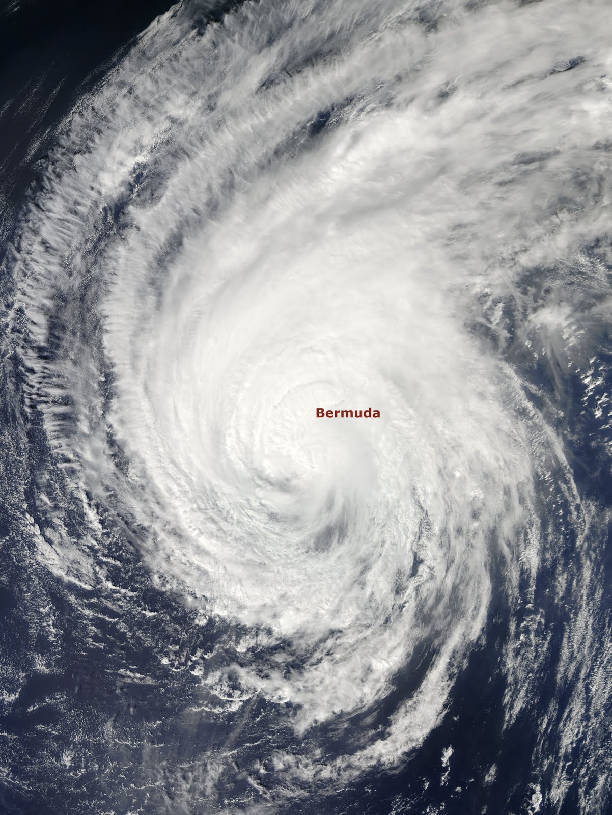
Well, after nearly a week of chasing the strongest hurricane thus far in the 2010 Atlantic season, I am finally back home in New York! Despite the storm’s weakened state upon its approach to Bermuda, chasing Hurricane Igor on that tiny north-Atlantic island was undoubtedly one of my greatest moments as a weather enthusiast!
The chase began on Thursday, September 16, as Greg Nordstrom and I were to depart from New York’s JFK airport but were delayed until Friday morning, September 17 due to severe weather in the area. We spent the night trying to sleep on the cold terminal floor, which sounds absolutely awful, but we did manage to have a bit of fun. We made friends with a girl by the name of Vanessa and the three of us huddled together, enjoyed some cocktails at the airport bar and tried to make the most of the situation.
On Friday morning the flight departed and arrived as smooth as could be. Upon arrival in Bermuda a local journalist by the name of Patricia contacted us and she was doing a story on Hurricane Igor and the storm chasers that were invading her island nation. We spent a few days before Igor’s landfall traversing the island with Patricia and we are so grateful for that opportunity, for without her guidance we would never have seen the things we did! From viewing roaring, crashing waves on Bermuda’s south shore to witnessing locals boarding up their homes in the lovely neighborhoods that line Bermuda’s coast – it was truly a unique experience.
On Friday afternoon Hurricane Igor began to somewhat deteriorate in organization as it officially made that northward turn and began its approach towards Bermuda. However, well in advance of what was a category 2 hurricane at the time (on its way to a category 1 from a strong category 4), Igor was responsible for a significant coastal battering. Surge was already rolling in along Bermuda’s south shore, especially into tributaries and inlets opening up to the fierce Atlantic. We were informed that areas we were looking at that appeared as a lake or river, were actually land – and this was at least 30 hours prior to Igor’s near direct hit.
Since Hurricane Igor was so massive in size, having been the third largest Atlantic hurricane ever recorded, conditions started going downhill on Saturday evening. By the time we went to sleep we were easily experiencing tropical depression conditions and by the middle of the night a weak tropical storm was in full effect.
Sunday was the day! By sunrise the winds were howling and the rain was pouring. The surf was kicking up more than it had in day’s prior and Bermuda was well entrenched in strong tropical storm conditions. Throughout the day the winds steadily increased and as evening dawned upon us we were officially experiencing Hurricane Igor, and would for the several hours to come.
During the height of the storm we took some risks but safety was on the top of our minds. While it might appear that we were too close for comfort, we made sound decisions and never felt that our life was in danger.
Although category 1 Hurricane Igor never made a direct hit to Bermuda, for the duration of the storm we were in the northeast quadrant – the strongest part of the storm, so we did feel the brunt of the impact. Many people said (locals and storm chasers alike) that Igor was the “best” and/or “strongest” category 1 hurricane they had ever experienced. I have not been in many but from what I witnessed in chasing this massive storm, I concur!
Throughout the storm as conditions and connectivity allowed, I kept everyone up to date on The Northeast QuadrantFacebook page. I know they really enjoyed seeing all the footage first-hand and I am so grateful to have been able to share the storm with them. I also submitted some footage to The Weather Channel which was aired on television and is still available online. I also conducted an interview with The Weather Channel via Skype, which aired live on Sunday morning just before the onset of Igor’s hurricane force winds.
Below you will find a movie I put together which combines the best footage from over 100 clips I filmed before and during the storm, as well as a slideshow of photos. Despite the dramatic feel these medium convey, as you can imagine it in no way showcases actually being in the storm!
Thank you so much for allowing me to share this experience with all of you – it is, after all, not only chasing Igor, but also me chasing my dream! Return to home
[Filmed Friday 9/17 and early Saturday 9/17] After a rough day of travel on Thursday, Greg and Devin finally made it to Bermuda Friday morning where they began to head on chase the monster of the Atlantic, Hurricane Igor. The record-breaking, powerful and excessively large hurricane is bearing down on the tiny island nation and the hosts of The Weathervein are capturing its every move as it inches closer to what could be a direct hit landfall on Sunday night. Check out this episode of The Weathervein and hear an update on the chase and see some amazing footage of Bermuda's coastal battering!
Well, in just a couple hours I will be meeting my good friend and pro storm chaser and meteorologist, Greg Nordstrom at JFK airport here in NYC. Together we will be leaving on a jet plane (perhaps not - a puddle jumper might do the job) to the tiny central Atlantic island nation of Bermuda.
Bermuda is in the direct path of major Hurricane Igor, now a category 4 packing winds of 140 mph with gusts over 160! While Igor will likely fluctuate in strength over the next few days, he will remain a dangerous, large and powerful tropical cyclone as he spirals closer to the island.
Igor should bring deteriorating conditions to Bermuda as early as Saturday morning, with tropical storm conditions developing Saturday afternoon through Sunday morning. Because of Igor's massive size, hurricane conditions should develop Sunday afternoon and could last right through the day on Monday. Late Monday Igor should be well northeast of the island.
Exactly what Igor delivers to Bermuda is yet to be seen, but you can bet Greg and I will do our best to bring you as much footage as possible before, during and after the storm! Our first plan is to check-in this evening, get a good night's sleep and wake up tomorrow morning to begin preparing us for the chase!
Wish us luck, and thanks for following!
Hurricane Igor's current projected path.
Satellite image of category 4 Hurricane Igor. Return to home
2010 was the fourth warmest U.S. summer on record!
NOAA's National Climatic Data Center (NCDC) confirmed this week that the summer of 2010 was, as expected and fully observed by many... HOT!
Published in NOAA's State of the Climate report and based on records dating back to 1895, the NCDC notes that although the entire country experienced the fourth warmest summer on record, three climate regions in the continuous United States had temperatures in the top five: the southeast (warmest), the central (third warmest) and the northeast (fourth warmest). Several cities broke summer temperature records, including New York, Philadelphia, Trenton, Wilmington, Tallahassee and Asheville.
Here are some highlights from the report: NCDC's Climate Extremes Index (CEI) for summer 2010 was about one-and-a-half times its historical average
The northeast climate region experienced its warmest January-August period with an average temperature more than 3.4°F above the long-term average
The majority of the U.S. had above-average temperatures last month. No state experienced an average temperature significantly below its long-term average
Maine, New Hampshire, Vermont, Rhode Island, Connecticut and New Jersey each had their warmest year-to-date period and all of the Northeastern states ranked in the top ten percent of warmest periods on record
Only Florida and Texas had below normal temperatures for the entire year so far
Learn more about these interesting summer of 2010 facts here.
It should be noted that several weather forecasting models predict cooling in months and years ahead, so if you're like me and found this past summer difficult to deal with, relief might be in sight!
Major Hurricane Igor is buzz-sawing its way slowly through the central Atlantic and remains a powerful category 4 storm! As of now, Igor's projected path brings it dangerously close to Bermuda late this coming weekend. Behind Igor Tropical Storm Julia is gathering strength and while it could become a hurricane over the next day or so, it too should remain a "fish storm." Another area of disturbed weather in the central Caribbean is under invest for potential development which as of now has been slow to non-existent to occur, but that could change in coming days as it makes its way towards the Yucatan Peninsula. For the latest on this very active time in the tropics and for a look ahead at the next couple weeks, check out this episode of The Weathervein!
Last week NASA and NOAA reported that the third and final spacecraft in the GOES N-P Series of geostationary environmental weather satellites known as GOES-15, has successfully completed five months of testing and has been accepted into service.
The GOES fleet help NOAA forecasters track life-threatening weather and it is one of the most useful satellites, providing a constant stream of data and imagery as it observes clouds, ocean temperatures, winds, atmospheric properties, severe storm systems, fires and many other environmental parameters covering more than 50 percent of the Earth's surface.
GOES-15 has already started to deliver high-resolution photos from space (see image above of Hurricane Danielle), including the first visible and infrared images of Earth taken by its imager instrument, and the first image of the sun taken by its solar X-ray imager instrument.
GOES-15 will be placed in an on-orbit storage location at 105 degrees west longitude should one of the operational GOES satellites degrade or exhaust their fuel. It will share a parking space with GOES-14, currently in the same storage orbit. Both satellites can be made operational within 24 hours to replace an older satellite.
A recent report by the National Academy of Sciences analyzes climate predictions and the difficult reality of the complex interactions between Earth's ocean, atmosphere and land; and the role they play in determining long-range climate forecasts. The report, "Assessment of Intraseasonal to Interannual Climate Prediction and Predictability," is the result of a NOAA requested study and recommends strategies and best practices for improving these complex and difficult predictions.
People all over the world rely on accurate short-term climate forecasts on timescales ranging from a few weeks to a few years to make more informed decisions. To that extent the report is recommending the following in dealing with the key shortcomings and strategies needed to make more accurate climate forecasts:
Continue research to better understand and use information from key sources of climate predictability, and interactions between the ocean and atmosphere, atmosphere and land, as well as volcanic eruptions, greenhouse gases and land use changes.
Improve the basic building blocks of climate forecasts through better physical climate models, making more sustained physical observations, better incorporating observations into forecast systems, and increasing collaboration between forecast agencies and stakeholders in developing and implementing forecast strategies.
Adopt best practices such as working more closely with research communities, particularly universities; making data that feed into and come out of forecasts publicly available; minimizing subjective forecast components; and using forecast metrics that better convey to the public the probability aspects of forecasts.
The report also highlights Madden-Julian Oscillation (MJO) events and their powerful influence on making climate predictions and long-term weather patterns. MJO events have been known to trigger the beginning and end of the Asian and Indian monsoons and influence the development and evolution of El Niño, hurricanes and weather in Earth's mid-latitudes. The report notes that scientists want to incorporate information about the MJO more accurately into the computer models that agencies around the world use to predict weather and climate.
For more information the complete report can be downloaded here.
Yesterday on Facebook I was admiring some graphics posted by Michael Laca, which using computer generated scenarios, depicted SLOSH (Sea, Lake, and Overland Surge from Hurricanes) inundation "worst-case" storm surge situations for several locations in Florida. Michael, a veteran hurricane chaser with over 25 years experience, runs the website TROPMET.COM, and after seeing these startling graphics my interest was immediately sparked to see what would happen "if" a major hurricane barreled into a northeast location from New Jersey to Cape Cod, including New York City. Michael gladly helped me out and produced the SLOSH inundation maps below using the MOM (Maximum Of Maximum) algorithm for each surge basin, which is agnostic of a specific track.
A couple things to note: The SLOSH analysis typically considers hypothetical scenarios – from 10 different directions, four forward speeds, five intensities and 10 to 20 landfall points within a basin, resulting in anywhere from 2,000 to 4,000 combinations of storm scenarios. The program then analyzes each combination and generates a MEOW (Maximum Envelope of Water) for all variations of similar scenarios (such as a category 4, moving northwest at 15 mph, making landfall at 20 different locations within the basin), and then retains the highest surge value at each grid square. The MOM then preserves each of the highest values from each MEOW, resulting in a graphic depicting the highest surge value for any point within the basin across all possible combinations of storms.
So what does that all mean? The maps below show the worst-case scenario at any one point when you consider ALL possible scenarios. That does not mean that for one specific storm scenario, that all areas shown in these maps will experience a "worst-case" surge, since each storm's size, strength, and forward speed will dramatically change the inundation at any particular location. It should also be stressed that these maps are only intended as guidance and should not be used to make decisions on specific evacuations always listen to emergency management and local officials when it comes to an actual event.
Worst case scenario for Manhattan / Hudson River, New York. Exceptionally high surge values of 30–32 feet above MSL (Mean Sea Level) can be expected in several locations, with widespread inundations between 20–25 feet experienced elsewhere.
Worst case scenario for Long Island, New York. Exceptionally high and widespread surge values of 30–33 feet above MSL can be expected along Atlantic facing coastal locations, with extensive inundations between 15–20 feet experienced elsewhere.
Worst case scenario for western Long Island, New York. Exceptionally high and widespread surge values of 30–33 feet above MSL can be expected along Atlantic facing coastal locations, with extensive inundations between 15–20 feet experienced elsewhere.
Worst case scenario for New Jersey / Delaware Bay. Highest surge values of 18–20 feet above MSL can be expected in several locations, with extensive inundations between 10–15 feet experienced elsewhere.
Worst case scenario for Providence, Rhode Island / Cape Cod, Massachusetts. Extremely high surge values of 35–39 feet above MSL can be expected in isolated locations at the heads of rivers and bays, with widespread inundations between 15–20 feet experienced elsewhere.
Tropical Storm Hermine is spinning up and strengthening in the southwest Gulf of Mexico and could become a minimal hurricane prior to landfall in extreme northeast Mexico or far southeast Texas late tonight. Meanwhile, the low pressure in the central Atlantic associated with former Tropical Storm Gaston will soon be approaching the northern Leeward Islands and it's future track and intensity remain questionable. Find out what's going on with these systems, what else might be brewing in the Atlantic, and hear a recap of Devin's Hurricane [Tropical Storm] Earl chase in Cape Cod, Massachusetts in this episode of The Weathervein!
September 2–3, 2010 – Chatham, Massachusetts, Cape Cod
Well, I am back from chasing Hurricane Earl in Chatham, Massachusetts on the far southeast tip of Cape Cod. Despite Earl's weakened state, having made its closest approach as a strong tropical storm, the experience was unforgettable!
I began tracking Earl the moment it emerged from the west coast of Africa into the Atlantic Ocean as a well-defined tropical wave which became Tropical Depression #7 on August 25, and later that day became Tropical Storm Earl. Fighting shear and the outflow from major Hurricane Danielle, Earl was slow to get its act together, but as it approached the northern Leeward Islands on August 29, it was game on!
Earl became a monster category 4 hurricane on August 30 and fluctuated in intensity while remaining a major hurricane as it moved northwestward towards the mid-Atlantic coast of the United States. Earl weakened to a category 2 hurricane as it neared the North Carolina coast and further weakened to a strong tropical storm as it neared Cape Cod and surrounding islands.
Earl's forecast sure was tricky, but ya know... I have give it up for the computer models! They handled this storm extremely well, maintaining convergence for days on a "just offshore" scenario. Many folks speculated that Earl could or would make landfall on the North Carolina coast or Cape Cod (or even Long Island), but the evidence available showed otherwise. I am not a professional forecaster, but I do have common sense to believe scientific evidence, and it is that evidence that eventually made this forecast pan out as expected.
I want to 'shout out' to my good friend Greg Nordstrom who called the scenario that panned out well in advance of it doing so. Greg maintained the offshore path in his forecasts for a good week prior to it taking place and he even nailed the mileage the center of circulation would track in it's closest approach to the U.S. coastline. I also need to shout out to Greg in thanking him for staying in touch with me while on my chase, providing constant updates on Earl's current location and intensity at the time. His input helped put me in the closest position on the Cape to witness the 'worst' (or 'best') of the storm in a mindful, safe manner.
That said, here's a video and some photosthat I captured during the chase...
I hope you all enjoyed this recap and footage. Before I conclude I'd like to highlight a couple of my 'personal highs' of the chase...
While on the beach in Chatham I stumbled upon (okay, I admit there was a bit of stalking involved) The Weather's Channel's Paul Goodloe who was kind enough to speak with me for a bit and even took took the time to suggest some great places to ride out the storm. His advice was great and as you saw above – we captured some great shots!
I was also granted a surprise interview with CBS News' Randall Pinkston who was was being followed by a cameraman filming their own coverage of the storm. Randall nicely asked what I was doing there, riding out the storm!? I explained I was chasing Earl and within seconds I had a camera on me and a microphone pointed towards my face... and the result – this interview!
Well there you have it! I look forward to bringing you even more from a bigger, stronger storm in weeks to come!
Hurricane Earl is about to make his presence known on the east coast! How much of an impact will Earl bring? Well, that is in his hands now, but if you are in the Outer Banks of North Carolina or Cape Cod, Massachusetts and outlying islands, you can expect to feel the brunt of this hurricane as it inches near and passes dangerously close offshore. Find out in this episode of The Weathervein exactly who will be affected by Earl, what the conditions could be like in your area, and what you need to do to prepare NOW!
An online video talk show offering a blood pumping new look at weather from a personal perspective!
The Northeast Quadrant Radar
About The Northeast Quadrant
The Northeast Quadrant is a highly informative blog and global interactive social community for the weather obsessed, written and managed by the weather obsessed!
Near daily blog posts and news shares about ever-changing weather patterns, the evolution of dynamic storm systems, the controversy surrounding climate change; and its effects on our cities, nation and the world, The Northeast Quadrant takes you beyond the weather and brings you closer to science through its unique presentation of incredible news stories and vibrant personal experiences! With thousands of web hits directly on the blog, hundreds of Facebook fans, and Twitter followers, and an overwhelming viewer audience on YouTube, The Northeast Quadrant continues to grow!
Bookmark and subscribe to http://northeastquadrant.blogspot.com/ and enjoy! In doing so you'll join the global community from countries around the world that regularly visit The Northeast Quadrant.
What are people saying about The Northeast Quadrant?
"Congratulations to The Northeast Quadrant for making weather fun! This is not the kind of information you get from your local weatherperson." – Janette from Washington, DC
"I am in the midst of grueling Navy Weather Forecasting school. It's fun sometimes, but we don't really get into anything outside of the subject matter. I appreciate The Northeast Quadrant because it's an interesting look at weather and facts. It provides a much needed break from mundane, tedious weather lessons! Thanks Devin!" – Mack from Biloxi, Mississippi
"I really enjoy reading The Northeast Quadrant! Devin does a great job and keeps things interesting. You can see the passion he has for the tropics and that's something I always respect! I have learned as a teacher of meteorology, that you can't teach passion – you either have it, or you don't!" – Greg from Starkville, Mississippi
"Throughout all the recent Icelandic volcanic news, we at Know Your Money like to keep updated with blogs to discover their opinion of what is going on. The Northeast Quadrant offers a great deal of interest to us with regards to its intake on weather etc., and its impact on the economy... so thank you!" – Claire from United Kingdom
"I visit The Northeast Quadrant at least once a week for weather and science updates on things happening around the world. What I often find interesting is that I will read The Northeast Quadrant in the early part of the day and learn something that isn't on the news until later that night. I would be remiss if I didn't mention the fantastic pictures everyone sends in from all over!" – Staci from Union, New Jersey
"I visit The Northeast Quadrant at least 3-5 times a week. I love the pictures and funny stories, articles, quotes, etc. The blog is a good resource, it's entertaining and has valuable information. It has actually made me more interested in what is going on with the weather and why things happen." – Glen from Orem, Utah
"I find myself visiting The Northeast Quadrant more than I ever expected! I enjoy seeing Devin act so funny when he reports on various weather phenomenon. He really makes me like weather, and I particularly enjoy the photos and videos. The Northeast Quadrant has actually changed my perspective on weather and science." – Meghan from Silver Spring, Maryland
"I love The Northeast Quadrant! The information given to me is always accurate and informative. When we were listening to the news about upcoming storms this past winter, I relied on The Northeast Quadrant more than the local news. I liked watching Devin at the East River reporting and nearly getting blown away! There were always updates every few hours, and in fact I was able to prepare in advance of the storm. I also enjoy looking at and submitting personal photos pertaining to the weather!" – Robin from Edison, New Jersey
Marketing and Communications Professional; Weather Enthusiast; Recreational Storm Tracker and Reporter; and Amateur Photographer
Ever since I was a young boy I loved the weather!
There was very little that excited me more than watching The Weather Channel since its inception in 1982. Bringing weather to life was the Channel's goal, and it delivered! I remember watching the local forecast as intense lines of storms progressed towards Edison, New Jersey (where I grew up), and being called by my father to join him on the front porch as he watched the storms close in on our neighborhood. I'd run back and forth between the gusty front porch that lied beneath the darkening sky to the cool air-conditioned living room, starring at the television as I glared at the storms getting closer and closer. As the line of vibrant red's and orange's intensified, so did my interest! My obsession for weather was born, and that's where it started!
With the tools I needed at my disposal I continued to closely follow various weather phenomenon: deadly mid-western tornado outbreaks, extreme Mississippi River flooding, Hurricanes Hugo and Andrew, crippling northeastern blizzards like the '93 Superstorm, earthquakes in the Golden State, volcanoes along the Pacific Rim... you name it!
Nearly 30 years later, those who know me well would say I have not changed all that much.

 Extreme conditions such as warm sea-surface temperatures are fueling an active hurricane season, but they are taking their toll on the Atlantic basin's tropical coral reefs.